The previous guide is a little bit old so I decided to update it with the latest possible FW, latest maps, and updated risk areas.
LATEST FIRMWARE: N42c (final update - SatNav support discontinued after 2016).
LATEST MAPS: EUROPE 2023-1 (For Eastern Europe (maps 2020-2) use this LINK)
LATEST RISK AREAS/RADARS: EU RADARS 2023.8 (AUGUST 2023 Update)
All files are available in their respective parts of the guide.
UPDATING THE FIRMWARE
1. Check your installed firmware version via SETUP -> Settings -> Version Information
2. If you see N42c anywhere in the presented firmware version you already have the latest firmware and you do not need to update it. You can move to the MAP updating part of the guide. If you do not have the latest version, proceed to step 3.
3. Download this file: LINK
4. Prepare USB 32GB or SD CARD formatted as FAT32, 64KB Cluster size.
IT IS IMPORTANT THAT YOU FORMAT VIA WINDOWS AND DO NOT USE QUICK FORMAT. The regular format will take more time, but it is absolutely necessary.
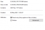
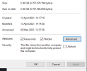
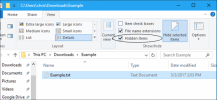
5. Extract the downloaded file and put all files into the ROOT of the USB/SD CARD. Enable in Windows to view "hidden files" and check if any file other than that of the firmware generated in the root of the USB / SD CARD. If you see any "rogue" files, delete them.
6. Turn on the car. Keep it running and insert the USB or SD CARD into their locations (SD CARD in front of the Console, USB under the armrest).
7. If you followed the guide the NG4 system will automatically detect and prompt you to start the update. Click yes on the console and wait for it to finish.
KEEP THE CAR RUNNING UNTIL IN FINISHES WITH THE UPDATE. You do not want the car to turn off and cancel the update. It could destroy your system.
8. When the NG4 resets check the firmware version again. If you see N42c the update was successful.
UPDATING THE MAPS
1. Download this file: LINK (2023-1 with original 2016 POI from PSA).
2. Prepare USB 32GB or SD CARD formatted as FAT32, 64KB Cluster size.
IT IS IMPORTANT THAT YOU FORMAT VIA WINDOWS AND DO NOT USE QUICK FORMAT. The regular format will take more time, but it is absolutely necessary.
3. Extract all files from the ZIP file to the ROOT of the USB / SD CARD. Enable in Windows to view "hidden files" and check if any file other than that of the map files included in the ZIP file generated in the root of the USB / SD CARD. If you see any "rogue" files, delete them.
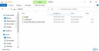
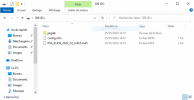
This is how your USB / SD Stick should look like after copying the files (everything should be the same, except the last file which is from the 2020 maps):
4. Turn on the car. Keep it running and insert the USB or SD CARD into their locations (SD CARD in front of the Console, USB under the armrest).
5. If you did everything correctly, the NG4 will recognize the new maps automatically and prompt you to start the update. It takes around 40-50 minutes. It is advised to drive around with the car in the meantime.
KEEP THE CAR RUNNING UNTIL IT FINISHES WITH THE UPDATE. You do not want the car to turn off and cancel the update. It could destroy your system.
5.1. If during the update the error 0x26E appears, just press "OK" and wait for the system to restart (leave the key or SD card connected) and it will continue the update.
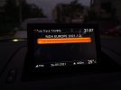
6. When it finishes, it will prompt you to press OK and remove the USB/SD CARD. Remove it and ONLY THEN press OK. After the NG4 System resets check the map version via SETUP -> When in the setup menu LONG PRESS SETUP -> GPS Information -> Map Versions. You should see "NG4 EUROPE 2023-Version-1.0".
UPDATING THE RISK AREAS
1. Download this file: LINK
2. Prepare USB 32GB or SD CARD formatted as FAT32, 64KB Cluster size.
IT IS IMPORTANT THAT YOU FORMAT VIA WINDOWS AND DO NOT USE QUICK FORMAT. The regular format will take more time, but it is absolutely necessary.
3. Extract all files from the ZIP file to the ROOT of the USB / SD CARD. Enable in Windows to view "hidden files" and check if any file other than that of the files included in the risk areas ZIP file generated in the root of the USB / SD CARD. If you see any "rogue" files, delete them.
4. Turn on the car and go to NAVIGATION -> SETTINGS -> IMPORT MY POINTS OF INTEREST
5. Select the Media you used (USB or SD CARD) and press YES to validate, that it will overwrite all previous risk areas.
6. After it finishes with the installation of risk areas (takes approx 10 seconds) a message appears to confirm a restart of the NG4 system and to remove the USB/SD CARD. Remove and press OK.
7. When the NG4 System restarts, all you have to do is to enable the risk areas/radars alerts in the Navigation menu. SETTINGS -> RISK AREA SETTINGS -> ENABLE all options.
8. You can check the latest risk areas/radars update in the same menu, that you used to check the MAP Version.
CAUTION. Proceed with every step at your own risk. It is extremely dangerous and it can destroy your NG4 system. No one on this forum or the forum itself is responsible for the caused damage and possible expenses.
I managed to install everything in one afternoon with no issues (my car is RCZ 2013 model). Take your time, follow the steps and it should be fine.
EDIT: Updated the link for the maps and updated the guide a bit - added a photo of how should USB / SD Card root directory look like after copying the files.
EDIT 2: Added the link for Eastern Europe maps - maps from 2020 (Courtesy of Ross_Russev)
EDIT #: Updated the links for MAPS and RISK AREAS - due to new updates.
LATEST FIRMWARE: N42c (final update - SatNav support discontinued after 2016).
LATEST MAPS: EUROPE 2023-1 (For Eastern Europe (maps 2020-2) use this LINK)
LATEST RISK AREAS/RADARS: EU RADARS 2023.8 (AUGUST 2023 Update)
All files are available in their respective parts of the guide.
UPDATING THE FIRMWARE
1. Check your installed firmware version via SETUP -> Settings -> Version Information
2. If you see N42c anywhere in the presented firmware version you already have the latest firmware and you do not need to update it. You can move to the MAP updating part of the guide. If you do not have the latest version, proceed to step 3.
3. Download this file: LINK
4. Prepare USB 32GB or SD CARD formatted as FAT32, 64KB Cluster size.
IT IS IMPORTANT THAT YOU FORMAT VIA WINDOWS AND DO NOT USE QUICK FORMAT. The regular format will take more time, but it is absolutely necessary.
5. Extract the downloaded file and put all files into the ROOT of the USB/SD CARD. Enable in Windows to view "hidden files" and check if any file other than that of the firmware generated in the root of the USB / SD CARD. If you see any "rogue" files, delete them.
6. Turn on the car. Keep it running and insert the USB or SD CARD into their locations (SD CARD in front of the Console, USB under the armrest).
7. If you followed the guide the NG4 system will automatically detect and prompt you to start the update. Click yes on the console and wait for it to finish.
KEEP THE CAR RUNNING UNTIL IN FINISHES WITH THE UPDATE. You do not want the car to turn off and cancel the update. It could destroy your system.
8. When the NG4 resets check the firmware version again. If you see N42c the update was successful.
UPDATING THE MAPS
1. Download this file: LINK (2023-1 with original 2016 POI from PSA).
2. Prepare USB 32GB or SD CARD formatted as FAT32, 64KB Cluster size.
IT IS IMPORTANT THAT YOU FORMAT VIA WINDOWS AND DO NOT USE QUICK FORMAT. The regular format will take more time, but it is absolutely necessary.
3. Extract all files from the ZIP file to the ROOT of the USB / SD CARD. Enable in Windows to view "hidden files" and check if any file other than that of the map files included in the ZIP file generated in the root of the USB / SD CARD. If you see any "rogue" files, delete them.
This is how your USB / SD Stick should look like after copying the files (everything should be the same, except the last file which is from the 2020 maps):

4. Turn on the car. Keep it running and insert the USB or SD CARD into their locations (SD CARD in front of the Console, USB under the armrest).
5. If you did everything correctly, the NG4 will recognize the new maps automatically and prompt you to start the update. It takes around 40-50 minutes. It is advised to drive around with the car in the meantime.
KEEP THE CAR RUNNING UNTIL IT FINISHES WITH THE UPDATE. You do not want the car to turn off and cancel the update. It could destroy your system.
5.1. If during the update the error 0x26E appears, just press "OK" and wait for the system to restart (leave the key or SD card connected) and it will continue the update.
6. When it finishes, it will prompt you to press OK and remove the USB/SD CARD. Remove it and ONLY THEN press OK. After the NG4 System resets check the map version via SETUP -> When in the setup menu LONG PRESS SETUP -> GPS Information -> Map Versions. You should see "NG4 EUROPE 2023-Version-1.0".
UPDATING THE RISK AREAS
1. Download this file: LINK
2. Prepare USB 32GB or SD CARD formatted as FAT32, 64KB Cluster size.
IT IS IMPORTANT THAT YOU FORMAT VIA WINDOWS AND DO NOT USE QUICK FORMAT. The regular format will take more time, but it is absolutely necessary.
3. Extract all files from the ZIP file to the ROOT of the USB / SD CARD. Enable in Windows to view "hidden files" and check if any file other than that of the files included in the risk areas ZIP file generated in the root of the USB / SD CARD. If you see any "rogue" files, delete them.
4. Turn on the car and go to NAVIGATION -> SETTINGS -> IMPORT MY POINTS OF INTEREST
5. Select the Media you used (USB or SD CARD) and press YES to validate, that it will overwrite all previous risk areas.
6. After it finishes with the installation of risk areas (takes approx 10 seconds) a message appears to confirm a restart of the NG4 system and to remove the USB/SD CARD. Remove and press OK.
7. When the NG4 System restarts, all you have to do is to enable the risk areas/radars alerts in the Navigation menu. SETTINGS -> RISK AREA SETTINGS -> ENABLE all options.
8. You can check the latest risk areas/radars update in the same menu, that you used to check the MAP Version.
CAUTION. Proceed with every step at your own risk. It is extremely dangerous and it can destroy your NG4 system. No one on this forum or the forum itself is responsible for the caused damage and possible expenses.
I managed to install everything in one afternoon with no issues (my car is RCZ 2013 model). Take your time, follow the steps and it should be fine.
EDIT: Updated the link for the maps and updated the guide a bit - added a photo of how should USB / SD Card root directory look like after copying the files.
EDIT 2: Added the link for Eastern Europe maps - maps from 2020 (Courtesy of Ross_Russev)
EDIT #: Updated the links for MAPS and RISK AREAS - due to new updates.
Last edited:

